Resource Library
A New Water Reality for Land-Based Industries
Land-based industries today face complex water-related challenges driven by climate change and evolving environmental demands.
According to the 2024 UNCCD report “The Global Threat of Drying Lands: Regional and Global Aridity Trends and Future Projections”, over 77% of the Earth’s surface has become permanently drier over the past 30 years, accelerating land degradation and putting long-term land productivity at serious risk.
These global trends are already being felt on the ground in the form of:
⚠️ Extreme weather events, such as prolonged droughts that reduce soil moisture and heavy rains causing flooding due to poor drainage, increasingly disrupt operations.
🔃 Shifts in productivity and growth cycles, driven by rising temperatures and altered precipitation patterns, impact forest yields and require adaptive plantation management.
💧 Water availability risks intensify as climate change and competing demands strain resources, threatening both land use and industrial facilities with scarcity.
In this context, water management is no longer just an operational concern; it is what distinguishes resilient, sustainable operations from those vulnerable to climatic and regulatory pressures.
A Scalable Approach to Smarter Water Management
To address these challenges, advanced monitoring and predictive techniques are essential. This article highlights key findings from the study “Evapotranspiration of Eucalyptus Forests Using Remote Sensing” , conducted by Suzano in partnership with Marvin, with contributions from Marvin experts: researcher Shai Abir (MSc in Atmosphere Science, trained in geosciences, meteorology, and climate science) and co-founder Aviv Gabbay (PhD in Computer Vision).
The study validated Marvin’s remote sensing technology as a reliable and scalable alternative for measuring evapotranspiration - a key indicator of water use in land based industries.
This capability is part of Marvin’s broader environmental monitoring solution, designed to help companies manage climate risk, optimize land use, and strengthen compliance through data-driven decision-making.
Evapotranspiration: A Key Indicator of Water Performance
According to the U.S. Geological Survey (USGS), evapotranspiration (ET) is the sum of plant transpiration and soil water evaporation to the atmosphere - the primary process by which water returns to the air in agricultural and forest ecosystems. In practical terms, it represents the main form of “water consumption” in these systems. Because transpiration is directly tied to plant metabolic activity, ET is also strongly correlated with plant growth and biomass accumulation, making it a key indicator of both water use and productivity.
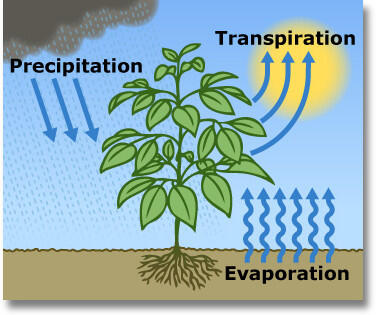
Monitoring evapotranspiration allows for understanding how vegetation responds to climatic conditions, soil types, and management practices, with direct impacts on productivity, sustainability, and long-term operational planning.
In addition, evapotranspiration directly influences the amount of water that remains in the system after rainfall or irrigation. By measuring how much water vegetation and soil absorb and release, it affects surface runoff—the water that flows over the land instead of infiltrating it. Excess runoff can cause erosion, flooding, and place pressure on infrastructure such as dams, reservoirs, and port zones. Accurate modeling of evapotranspiration helps anticipate these dynamics and reduces risks to both ecosystems and physical assets.
This level of understanding enables smarter, more strategic decisions such as:
- Identifying areas with higher water demand.
- Predicting environmental stress scenarios.
- Evaluating Water Use Efficiency (WUE) by plot.
- Supporting decisions regarding planting density, irrigation, and productive zoning.
- Modeling runoff potential to guide erosion control, mitigate flooding risks, and protect key infrastructure from hydrological stress.
The Challenge: Obtaining Reliable, Scalable Water Use Data
Evapotranspiration can be estimated through different methodological approaches, depending on the level of precision and scale required. Reference evapotranspiration (ETr) is commonly calculated using meteorological data and standardized models. However, ETr represents only the potential atmospheric demand for water under ideal conditions and does not reflect the actual water consumed by vegetation.
Actual evapotranspiration (ETa), on the other hand, incorporates real-world variables including crop stress, soil moisture, and land cover, offering more robust and representative insights into ecosystem functioning.
Traditionally, ETa has been measured using flux towers—high-precision instruments that are complex to install, costly to maintain, and limited to single locations. Recent advances in remote sensing technologies now enable the estimation of evapotranspiration from satellite imagery through scientifically validated algorithms, offering much broader spatial coverage and more frequent monitoring.
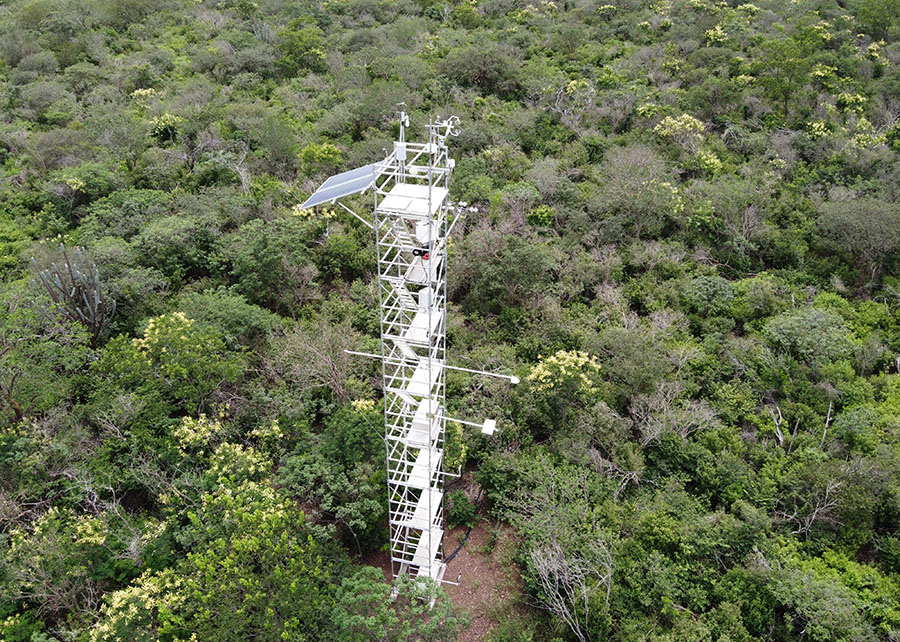
However, traditional measurement methods like flux towers or lysimeters are point-based, expensive, and lack operational-scale visibility.
Additionally, evapotranspiration varies significantly at the micro-regional level due to differences in climate, soil, and vegetation. This variability makes scaling analyses difficult, demanding solutions that effectively balance local accuracy with wide territorial coverage.
For companies to make decisions based on truly representative data, it is necessary to adopt solutions combining accuracy, spatial coverage, temporal coverage (historical reference) and continuous updates.
To meet this need, Marvin developed a proprietary remote sensing technology, which was rigorously tested for accuracy and scalability in a collaborative study conducted by Suzano, one of the world’s leading pulp producers.
The Study: Validation of Marvin’s Technology in Eucalyptus Plantations
In collaboration with Suzano, Marvin applied its satellite-based Ensemble modeling technology to measure evapotranspiration in eucalyptus plantations. The goal was to assess the solution’s accuracy compared to data obtained from flux towers and other established methodologies.
As explained by Shai Abir:
.png)
MSc in Atmospheric
Science and Marvin Researcher
“With the leaps in space tech and compute power, we’re finally unlocking the full potential of robust, physics-based evapotranspiration modeling at scale. This article showcases how advanced satellite imagery and Ensemble energy balance models can accurately map actual ET in eucalyptus plantations-something that was nearly impossible just a few years ago. For the forestry sector, this is a game-changer. It opens the door to smarter water use, optimized forest productivity, and real action on climate and sustainability risks-all at the landscape level.”
Want to read the full study? Click here to access the technical article.
Results: Accuracy, Validity, and Large-Scale Applicability
Statistical tests showed that Marvin’s technology was the only one demonstrating statistical equivalence with flux tower data, considered reliable for accurately estimating real evapotranspiration in the field, as illustrated in the graph below.
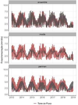
Marvin’s technology showed very high correlation with actual measurements, enabling continuous monitoring of water use with updated, auditable data applicable at large scale.
Marvin Solution: Intelligent Water Use Monitoring
"Our technology not only achieves precision comparable to field measurements but also delivers insights along decades back, visibility provided by our technology. So it all enables managers to make fast, reliable decisions to optimize water use” highlights Shai Abir.
Marvin offers an environmental monitoring platform based on remote sensing, integrating scientific algorithms, high-resolution thermal satellite imagery, and climatic data. The technology transforms evapotranspiration and water dynamics into clear, precise, and actionable insights, making water management tangible and empowering smarter decisions across all your operations.
Here’s how Marvin helps land-based companies respond to today’s most pressing climate-related risks:
- Risk Mitigation & Operational Intelligence
Marvin combines near real-time monitoring with satellite-based insights to help you understand and manage water dynamics across your operations — from field to facility. By identifying hydrological stress near rivers and critical assets, it supports timely decision-making, protects operational continuity, and helps mitigate risks driven by climate variability and upstream disruptions.

- Strategic Water Use and Compliance Readiness
Marvin delivers reliable water use metrics (like ET) to improve water efficiency, support sustainability reporting, and demonstrate proactive compliance with frameworks such as ESRS, TNFD, and CDP water disclosures. This visibility turns water into a strategic asset, providing tangible proof for full transparency with stakeholders and transforming resource management into a competitive advantage.

Conclusion: From Visibility to Sustainable Action
The study conducted with Suzano demonstrates that Marvin’s technology offers a robust alternative to traditional evapotranspiration measurements, with added benefits in scale, frequency, and applicability.
In a context where water is becoming a strategic asset, visibility into its use ceases to be merely a technical advantage - becoming an essential condition for competitiveness and business sustainability.
Marvin is ready to support land sector companies in transitioning to scalable, data-driven water management aligned with current demands for productivity and environmental responsibility.
Ready to turn water insights into action? Contact our specialists to discover how Marvin can help future-proof your operations.

Our Latest Resources

Full Compliance and 40% Faster Certifications Processing Time
How Technology Is Rewriting the Rules of Global Trade